
Saturday, October 15, 2011

Sunday, June 26, 2011
Abstract
Urban Transitions: Transit Oriented Development
I am studying four locations in New York City so that I understand how the subway impacts transitions in order to understand how to develop transit oriented developments. My research focuses on how the New York City subway stations impact urban transitions around them. Additional, my research looks into how the urban transition impacts the particular subway station. It is in my interest to conclude from my research that either the presence of the subway system is one reason for the urban transition or it is the urban transition that gives reason for the subway station.
To conduct my research, I looked at four areas within New York City: Columbus Circle, Atlantic Yards, Times Square, and the High line. Here I compared the history of the place’s development and subway stations to what they are today. From there, I took note of activity zones, access points of the subway system, and subway station within the area of transition; most importantly, whether the area had a subway station at all.
My results show that major activity zones occur within the boundaries that the subway access points create or the subway stations themselves create. In the case of New York City’s subway, not much has changed as far as station stops but there have been changes as far as access and usage of the station. I conclude that it is the transition that influences the subway, but it is the subway that gives some reasoning for the transition.
The High Line: Success
In my research, I take into account how efficient the development is with or without a subway station. In the case of the High Line, I find it to be a very popular and efficient place even without having a subway station. During my time there, I found it to be very busy throughout the day. While sitting in a restaurant just outside the High Line, I noticed large crowds would walk through about every 5 to 10 minutes. There would also be groups of people attempting to enter the exits. In the diagram below, I observed the following:
- the green spots being popular gathering places within the High Line
- the red being popular activity zones within the neighborhood
 |
| diagram by blogger |
The High Line: Access Points
 |
| diagram by blogger |
The are no plans for a future subway station specifically for the High Line but there are several lines that provide access. In the map above, entries and exits of the High Line are strategically placed in direct route to the subway stations just 2-3 blocks away. The access points are as follows:
- Gansevoort Street
- 14th Street (elevator access)
- 16th Street (elevator access)
- 18th Street
- 20th Street
- 23rd Street (elevator access coming soon)
- 26th Street
- 28th Street
- 30th Street (elevator access)
Public Transportation stops are listed as well...
Subway
- L / A / C / E to 14th Street & 8th Avenue
- C / E to 23rd Street & 8th Avenue
- 1 / 2 / 3 to 14th Street & 7th Avenue
- 1 to 18th Street & 7th Avenue
- 1 to 23rd Street & 7th Avenue
Bus
- M11 to Washington Street
- M11 to 9th Avenue
- M14 to 9th Avenue
- M23 to 10th Avenue
- M34 to 10th Avenue
Tuesday, June 21, 2011
The High Line: Subway Stations
 |
| map from High Line official website |
Friday, June 17, 2011
The High Line: Now
Today, the High Line has become an one and half mile elevated park; which is in the process of being completed. With inspiration from Promenade Plantee and Millennium Park, the park is an integrated landscape consisting of a staggered concrete pathway, plants that bloom year-round, lighting, seating, and gathering spots. It is used by locals, tourist, and even some celebrities.
 |
| photo by blogger |
 |
| photo by Earth Phtotography, Peter Visontay |
Thursday, June 16, 2011
The High Line: Early Days
The High line was originally a transition of Manhattan's railways. It was constructed in the 1930's to elevate freight trains above street level, eliminating 105 railroad crossing at street level. The 13 mile line ran from 34th Street to St. John's Park Terminal, Spring Street. The railway ran within the blocks oppose to along the avenue to avoid interference with elevated subways. The trains pierced through buildings,entering directly into factories and warehouses.
 |
| This is a file from the Wikimedia Commons |
The High Line: Research Significance
The High Line is an area where the dominant form of transportation is not clear. Taking note that there is no subway station for the specific location, one assumes that not many would use the subway to get there. However after mapping the closes stations, it can be said that the subway is a commonly used mode of transportation to the High Line. Counting the number of patrons using a particular station would provide the quantity of its use, but would not show the quantity using it for the High Line. Therefor this area would be significant in analyzing the question of my research.

Subway Stations & Activity Zones in Times Square

Times Square: Now

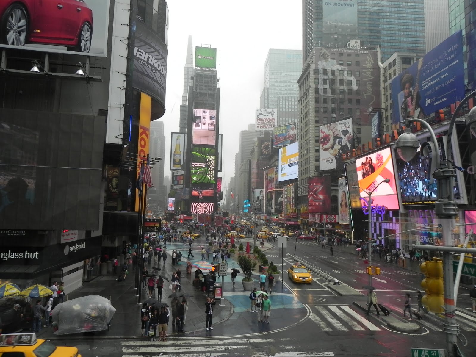
 Today, one can find Times Square in the midst of another transition as Disney has made it presence. Still a tourist spot, the presence of Disney has made the area more family oriented, with fun for all. In the past years, Times Square has become more crowded than ever. As a result, the city has made efforts to promote more pedestrian traffic and decrease vehicular traffic. The result may lead to an increase in the use of the Times Square Station.
Wednesday, June 15, 2011
Times Square: Transition Three


Saturday, June 11, 2011
Times Square: Transition One
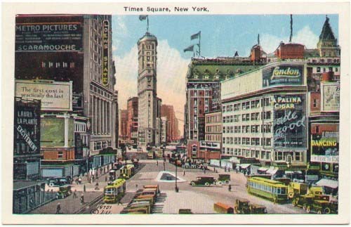
"It also created the city's first twentieth-century social and cultural center. The opening of the IRT stop at 42nd Street between Broadway and Seventh Avenue coincided with the New York Times's breaking ground on construction of its highly anticipated skyscraper headquarters. The two events combined to reconfigure Manhattan's midtown boulevard into a crossroads of recreation and commerce the likes of which had never before been seen in America." 1
 |
| image from New York Architecture |
 |
| image from New York Architecture |
1. A quote from "Down 42nd Street: Sex, Money, Culture, and Politics
at the Crossroads of the World"
by Marc Eliot
Long Acre Square to Times Square
 |
| photos from Shorpy Vintage Photo Blog |

Prior to 1904, Long Acre Square was a carriage-making district that later came to have a reputation as a low entertainment district. After the move of the Times building and becoming Times Square, the area transformed into a popular entertainment center. Times Square underwent its share of pitfalls and upbringings. Today, it has been overtaken by Disney being a place of entertainment and commerce.
Tuesday, June 7, 2011
New Station at Atlantic Yards
 |
| diagram by blogger |
 |
| image and animation below from Barclays Center website |
Atlantic Yards: The Future
 |
| image from Barclays Center website |
With the completion of the Barclays Center, the Atlantic Yards area of Brooklyn will no longer be just for locals but it will be a place for people of New York, New Jersey, and all visitors. In the development, a new station will arise, Atlantic Yards Barclays Center, which connects 9 lines and the LIRR becoming one of the most accessible venues in New York.
"No matter where you are in metro New York, you’re just minutes away from the excitement of the Barclays Center."
video and quote from Barclays Center Website
Atlantic Yards: Current Subway Stations & Activity Zones
Currently, the major activity zones occur within the Atlantic Center mall and along Flatbush Avenue. With future development of Atlantic Yards, the activity zone will shift using Atlantic Avenue as the datum.
 |
| diagram by blogger |
Atlantic Yards: Significance Now


Currently, Atlantic Yards is an undevelopment area. The locals of Brooklyn conveniently has a place to shop at the mall nearby. It also has two subway stations which sole purposes are to allow the residents travel in and out the neighborhood. They do not serve as major stations for getting patrons to "tourist" spots like Times Square.

Proposed Atlantic Yards
Atlantic Yards is currently proposed to be a mixed-use development which contains both residential and commercial spaces. It will also include a sports and entertainment venue as well as green space. Located at Atlantic Avenue and Flatbush Avenue, the site spans 22 acres over the original Vanderbilt Rail Yards.
The project is set to include:
The project is set to include:
- a sports and entertainment venue of 675,000 sq.ft.
- retail space of 247,000 sq.ft.
- office space 336,000 sq.ft.
- hotel of 165,000 sq.ft.
- affordable and market-rate housing of 6.36million sq.ft.
- an art venue
- eight acres of open space

Subscribe to:
Posts (Atom)