Saturday, October 15, 2011
Sunday, June 26, 2011
Abstract
Urban Transitions: Transit Oriented Development
I am studying four locations in New York City so that I understand how the subway impacts transitions in order to understand how to develop transit oriented developments. My research focuses on how the New York City subway stations impact urban transitions around them. Additional, my research looks into how the urban transition impacts the particular subway station. It is in my interest to conclude from my research that either the presence of the subway system is one reason for the urban transition or it is the urban transition that gives reason for the subway station.
To conduct my research, I looked at four areas within New York City: Columbus Circle, Atlantic Yards, Times Square, and the High line. Here I compared the history of the place’s development and subway stations to what they are today. From there, I took note of activity zones, access points of the subway system, and subway station within the area of transition; most importantly, whether the area had a subway station at all.
My results show that major activity zones occur within the boundaries that the subway access points create or the subway stations themselves create. In the case of New York City’s subway, not much has changed as far as station stops but there have been changes as far as access and usage of the station. I conclude that it is the transition that influences the subway, but it is the subway that gives some reasoning for the transition.
The High Line: Success
In my research, I take into account how efficient the development is with or without a subway station. In the case of the High Line, I find it to be a very popular and efficient place even without having a subway station. During my time there, I found it to be very busy throughout the day. While sitting in a restaurant just outside the High Line, I noticed large crowds would walk through about every 5 to 10 minutes. There would also be groups of people attempting to enter the exits. In the diagram below, I observed the following:
- the green spots being popular gathering places within the High Line
- the red being popular activity zones within the neighborhood
 |
| diagram by blogger |
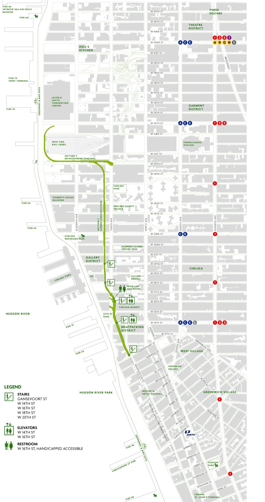
The High Line: Access Points
 |
| diagram by blogger |
The are no plans for a future subway station specifically for the High Line but there are several lines that provide access. In the map above, entries and exits of the High Line are strategically placed in direct route to the subway stations just 2-3 blocks away. The access points are as follows:
- Gansevoort Street
- 14th Street (elevator access)
- 16th Street (elevator access)
- 18th Street
- 20th Street
- 23rd Street (elevator access coming soon)
- 26th Street
- 28th Street
- 30th Street (elevator access)
Public Transportation stops are listed as well...
Subway
- L / A / C / E to 14th Street & 8th Avenue
- C / E to 23rd Street & 8th Avenue
- 1 / 2 / 3 to 14th Street & 7th Avenue
- 1 to 18th Street & 7th Avenue
- 1 to 23rd Street & 7th Avenue
Bus
- M11 to Washington Street
- M11 to 9th Avenue
- M14 to 9th Avenue
- M23 to 10th Avenue
- M34 to 10th Avenue
Tuesday, June 21, 2011
The High Line: Subway Stations
 |
| map from High Line official website |
Friday, June 17, 2011
The High Line: Now
Today, the High Line has become an one and half mile elevated park; which is in the process of being completed. With inspiration from Promenade Plantee and Millennium Park, the park is an integrated landscape consisting of a staggered concrete pathway, plants that bloom year-round, lighting, seating, and gathering spots. It is used by locals, tourist, and even some celebrities.
 |
| photo by blogger |
 |
| photo by Earth Phtotography, Peter Visontay |
Thursday, June 16, 2011
The High Line: Early Days
The High line was originally a transition of Manhattan's railways. It was constructed in the 1930's to elevate freight trains above street level, eliminating 105 railroad crossing at street level. The 13 mile line ran from 34th Street to St. John's Park Terminal, Spring Street. The railway ran within the blocks oppose to along the avenue to avoid interference with elevated subways. The trains pierced through buildings,entering directly into factories and warehouses.
 |
| This is a file from the Wikimedia Commons |
Subscribe to:
Posts (Atom)